Peck Park, San Pedro
SHORT RIDE
MEDIUM RIDE
LONG RIDE
S1

22 Miles. Rolling ride traveling in a clockwise direction around Palos Verdes Peninsula on P.V. South, P.V. West, P.V. North returning on N. Western Ave.
1300 Feet Elevation Gain.
S2
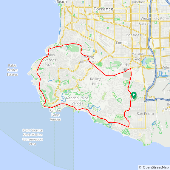
22 Miles. Rolling ride traveling in a counter clockwise direction around Palos Verdes Peninsula on P.V. North, P.V. West, P.V. South returning on S. Western Ave.
1300 Feet Elevation Gain.
M1

35 Miles. Rolling ride traveling in a counter clockwise direction around Palos Verdes Peninsula on P.V. North, P.V. West, P.V. South returning on S. Western Ave.
1300 Feet Elevation Gain.
M2

35 Miles. Rolling ride with one hill traveling in a counter clockwise direction around Palos Verdes Peninsula. This route takes you up & down Hawthorne, rolling along P.V. North, P.V. West & returning on P.V. South and S. Western Ave.
2400 Feet Elevation Gain.
M3

37 mile hilly ride in a counter clockwise rotation with climbs up Hawthorne from the coast side, Palos Verdes East with an option to go up Crest to the Radar Station (40 miles).
M4

32 Mile hilly ride in the counter clockwise direction with one major climb up Palos Verdes East and an option to go up Crest to the Radar Station for an additional 3.2 miles.
L1

43 Miles. Hilly ride traveling in a counter clockwise direction around Palos Verdes Peninsula. This route takes you up & down P.V. East rolling around P.V. North, P.V. West, P.V. South and S. Western Ave.
2800 Feet Elevation Gain.
L2

46 Miles. Hilly ride traveling in a counter clockwise direction around Palos Verdes Peninsula. This route takes you up P.V. East & Crest to the radar dome. After a fast downhill on Crest you continue on P.V. East rolling around P.V. North, P.V. West, P.V. South and S. Western Ave.
3400 Feet Elevation Gain.
L3

40 mile hilly ride in a counter clockwise rotation with climbs up Hawthorne from the coast side, Palos Verdes East and a trip up Crest to the Radar Station.
L3 (starts from McDonalds)

40 mile hilly ride in a counter clockwise rotation with climbs up Hawthorne from the coast side, Palos Verdes East and a trip up Crest to the Radar Station.
XL1

50 Miles. Hilly ride traveling in a clockwise direction around Palos Verdes Peninsula. This route takes you up & down P.V. East & Hawthorne with a fast downhill on Crenshaw returning on P.V. North and N. Western Ave.
3400 Feet Elevation Gain.
XL2

51 Miles. Hilly ride traveling in a counter clockwise direction around Palos Verdes Peninsula. This route takes you up & down P.V. East & Hawthorne with a fast downhill on Crenshaw returning on P.V. South and S. Western Ave.
3400 Feet Elevation Gain.
XL3

51 Mile Hilly ride traveling in a counter clockwise direction around Palos Verdes Peninsula. The first climb off of P.V. South is up Via Coronel with a fast downhill on Hawthorne to rejoin P.V. South continuing on to the next climb up P.V. East & Crest to the radar dome. After a fast downhill on Crest you continue on P.V. East rolling around P.V. North, P.V. West, P.V. South and S. Western Ave.
4200 Feet Elevation Gain.
XL4

53 Miles. Hilly ride traveling in a counter clockwise direction around Palos Verdes Peninsula. The first climb off of P.V. South is up Via Coronel with a fast downhill on Hawthorne to rejoin P.V. South continuing on to the next climb up P.V. East & Crest to the radar dome. After a fast downhill on Crest you continue on P.V. East rolling around P.V. North. At Malaga Cove there is one last climb up Via Del Monte and another fast downhill on Hawthorne to rejoin P.V. South finishing on S. Western Ave.
5000 Feet Elevation Gain.
DIRECTIONS: Peck Park, San Pedro (25)
- Take 110 Freeway south to Gaffey St N.
- Make an immediate left on W. Summerland Av for 1.0 mile.
- Turn right on N. Western Av for 0.2 mile and turn right on Crestwood St.
- Go 0.2 mile and park at end by Gym.