Yorba Regional Park, Anaheim Hills
SHORT RIDE
MEDIUM RIDE
LONG RIDE
S1

31 Miles. Ride up to Corona via the Santa Ana River Bike Trail and Green River Rd and Return. 1500 Feet Elevation Gain
L1

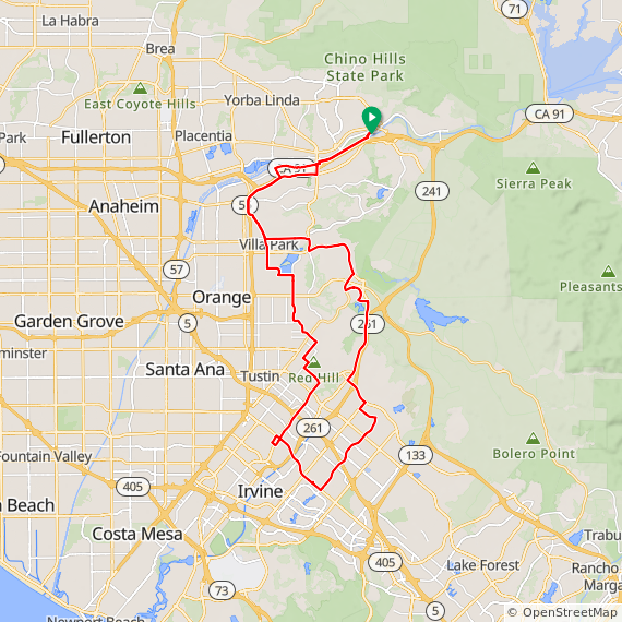
43 Miles. Rolling to Hilly ride thru Orange, Tustin, Irvine, & returning thru Villa Park. 1250 Feet Elevation Gain.
L2

42 Miles. Rolling to Hilly ride thru Orange, Tustin, Irvine, & returning thru Villa Park.
1250 Feet Elevation Gain.
L3
43 Miles. Rolling to Hilly ride thru Orange, Tustin, Irvine, & returning thru Villa Park.
1250 Feet Elevation Gain.
L4
46 Miles. Rolling to Hilly ride thru Orange, Tustin, Irvine, & returning thru Villa Park.
1250 Feet Elevation Gain.
L5
53 Miles. Rolling to Hilly ride up the Santa Ana River Trail out to Corona and Lake Mathews. Returning thru Corona and the Santa Ana River Trail. 3000 Feet Elevation Gain.
L6 TOMS FARM

50 Miles. Rolling to Hilly ride up the Santa Ana River Trail out to Corona to Tom's Farm. Returning thru Corona and the Santa Ana River Trail. 2600 Feet Elevation Gain.
L7 GRAVEL ROUTE

48 Mile ride out to Corona and then up Skyline Drive Trail to Blackstar Canyon and Santiago Canyon over to Jamboree and then up Santiago Creek Trail to Oak Trail and Serrano, Nohl Ranch and Imperial Hwy. 4500 feet of elevation gain
L8

44 Miles. Rolling to Hilly ride thru Orange, Tustin, Irvine, & returning thru Villa Park. 1250 Feet Elevation Gain.
L9

42 Mile ride goes out Green River to Corona and Chino and back. The ride is mostly flat with a few rolling hills on the way out and a couple of hills on the way back. 1300+ feet of elevation gain.
L10
43 Mile rolling to hilly ride thru Orange Park Acres, down Jamboree, Orchard Hills, Northwood Point, Irvine, Tustin Ranch, North Tustin, Villa Park and Orange Hills. 1200 feet of elevation gain.
L11 Gravel

53 mile ride down Oak trail, Santiago Creek trail, Horseshoe trail, down Jamboree and back up the Mountains to the Sea/Peters Canyon trail to the rest stop at Santiago Hills Park. You then ride out Santiago Canyon to Silverado Canyon and Black Star Canyon over to Skyline down to Corona and return on Green River and the SART. 5000+ feet of elevation gain.
XL1
64 Miles. Rolling to Hilly ride thru Orange, Tustin, Irvine, Mission Viejo & returning thru Santiago Cyn Rd and Villa Park.
2800 Feet Elevation Gain.
XL2
63 Miles. Rolling to Hilly ride thru Orange, Tustin, Irvine, Mission Viejo & returning thru Santiago Cyn Rd and Villa Park.
2800 Feet Elevation Gain.
XL3
64 Miles. Rolling to Hilly ride thru Orange, Tustin, Irvine, Mission Viejo & returning thru Santiago Cyn Rd and Villa Park.
3000 Feet Elevation Gain.
XL4
66 Miles. Rolling to Hilly ride thru Orange, Tustin, Irvine, Mission Viejo & returning thru Santiago Cyn Rd and Villa Park.
3000 Feet Elevation Gain.
XL5 HIGHLAND ROUTE

65 Miles. Hilly ride out through the foothills of Corona and up to Lake Mathews returning through Norco and by the Corona Airport and a final loop in Yorba Linda. 4700 Feet Elevation Gain.
XL6 LOWLAND ROUTE

63 Miles. Hilly ride out through the foothills of Corona and up to Lake Mathews returning through Norco and by the Corona Airport and back on the Santa Ana River Trail. 3800 Feet Elevation Gain.
XL7 METRIC

64 Miles. Rolling to Hilly ride thru Orange, Tustin, Irvine, Great Park, Lake Forest, Mission Viejo & returning thru Santiago Cyn Rd and Villa Park. 2800 Feet Elevation Gain.
XL9 METRIC

64 Mile ride goes out to Corona, Chino, Chino Hills, Diamond Bar, Brea Canyon and Yorba Linda. 2500 feet of elevation gain.
XL10 Metric

64 Mile hilly ride thru Orange Park, Santiago Canyon, Mission Viejo, Lake Forest, Irvine, Tustin Ranch, North Tustin, Villa Park and Orange Hills. 2800 feet of elevation gain.
XL11 LOWLAND METRIC

63 Miles. Hilly ride out through the foothills of Corona and out to Tom's Farm returning through Norco and by the Corona Airport and back on the Santa Ana River Trail. 3500 Feet Elevation Gain.
XL12 HIGHLAND METRIC
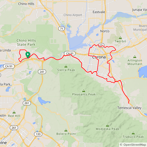
65 Miles. Hilly ride out through the foothills of Corona and out to Tom's Farm returning through Norco and by the Corona Airport and a final loop in Yorba Linda. 4000 Feet Elevation Gain.
XL13 Highland Metric

67 Mile hilly ride out through the foothills of Corona and out to Tom's Farm with a new loop up Trilogy returning through Norco and Corona and a final loop in Yorba Linda. 4400 Feet Elevation Gain.
ROUTE SLIP
DIRECTIONS: Yorba Regional Park, Anaheim (24)
- Take the 91 Freeway to Imperial Hwy exit North.
- Go 0.3 mile to La Palma Ave. and turn right.
- Go 1.9 mile and turn right at main park entrance.
- Go .1 mile past main gate and turn left.
- Go .5 mile to parking area # 11.
- Check-in is at shelter # 4.
There is a $5.00 Entry Fee for all vehicles entering the Park!