The Square, Irvine
SHORT RIDE
MEDIUM RIDE
LONG RIDE


S8


S15

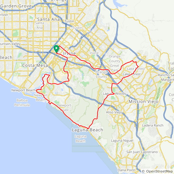
27 Miles. Flat to rolling ride thru Irvine, Newport Beach & UCI.
525 Feet Elevation Gain.

S18

27 Miles. Flat to rolling ride thru Irvine & Newport Beach.
750 Feet Elevation Gain.
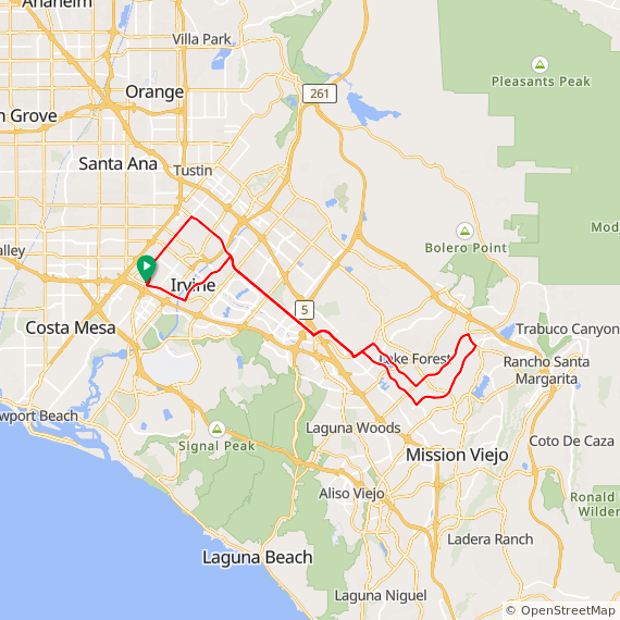
S19

25 Miles. Hilly ride thru Irvine, Tustin, Newport Beach with a climb up San Joaquin Hills.


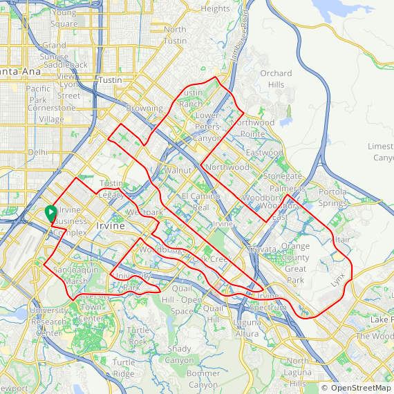
S23
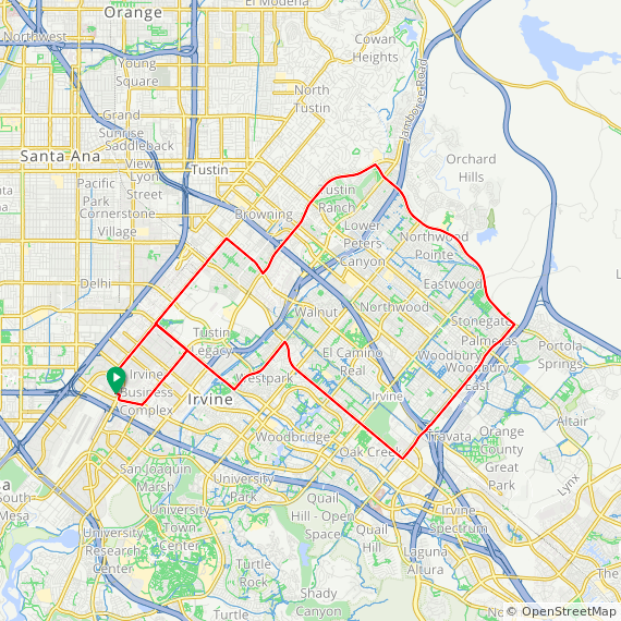
29 Miles. Flat ride through Irvine past local bike shops
S24
28 Miles. Flat ride around Irvine, visiting 5 local bike shops

M2
30 Miles Hilly ride through Irvine, Laguna Canyon, PCH, Newport Coast, and UCI.
1,200 Feet Elevation Gain.
M3
31 Miles. Hilly ride thru Irvine, Newport Beach & Laguna Beach returning up Laguna Canyon.


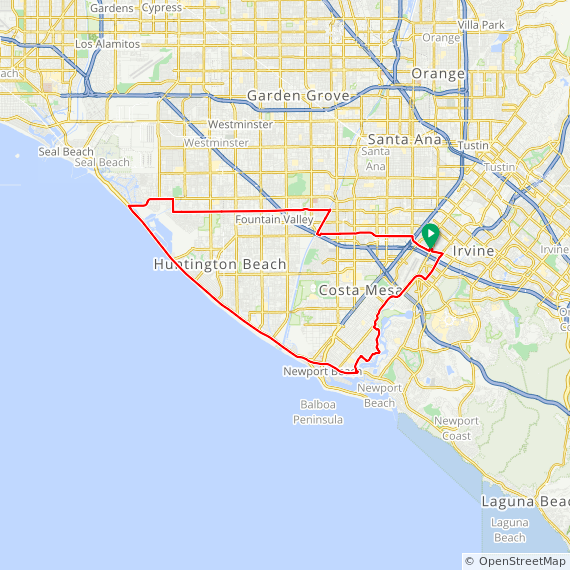
M7

32 Miles. Flat to Rolling ride thru Costa Mesa, Newport Beach, Huntington Beach, Fountain Valley & Santa Ana.
430 Feet Elevation Gain.
M8

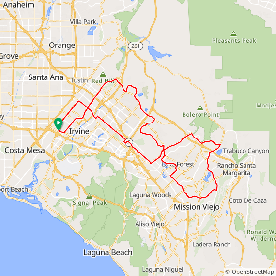
32 Miles. Flat to Rolling ride thru Irvine & Lake Forest.
500 Feet Elevation Gain.
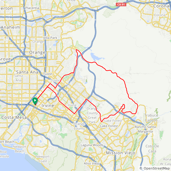
M9

33 Miles. Rolling to Hilly ride thru Irvine & Lake Forest.
1000 Feet Elevation Gain.

M11

33 Miles. Rolling ride thru Irvine, Laguna Beach & Newport Beach.
900 Feet Elevation Gain.
M12

33 Miles. Flat to rolling ride thru Irvine & Lake Forest.
900 Feet Elevation Gain.
M13

34 Miles. Rolling ride thru Irvine & Lake Forest.
800 Feet Elevation Gain.


M17

34 Miles. Rolling ride thru Irvine, UCI & Newport Beach.
1050 Feet Elevation Gain.
M18
34 Miles. Flat to rolling ride thru Santa Ana, Fountain Valley, Huntington Beach returning on PCH to Newport Beach and Irvine.
480 Feet Elevation Gain.
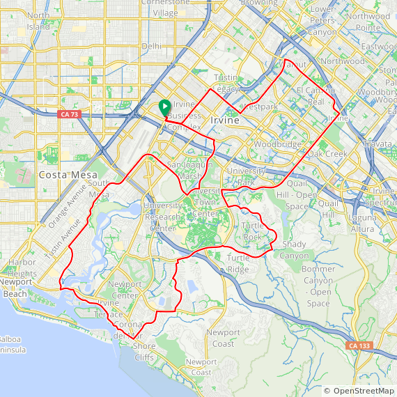


M22

35 Miles. Rolling to Hilly ride thru Irvine & Newport Beach with a little climb up Newport Coast and Turtle Rock.
1900 Feet Elevation Gain.

M24

37 Miles. Flat to hilly ride thru Irvine, Newport Beach & Laguna Beach.
1300 Feet Elevation Gain.
M25

35 Miles. Flat to rolling ride thru Santa Ana, Fountain Valley, Huntington Beach returning thru Newport Beach & Irvine.
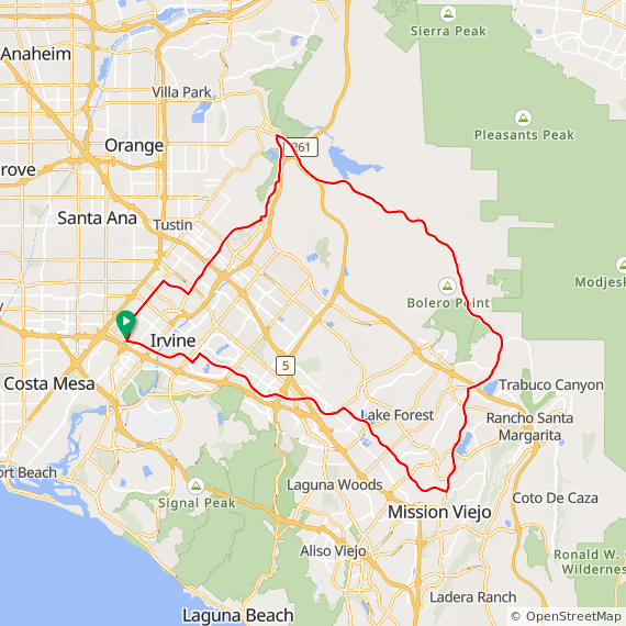
M26

37 Miles. Rolling to Hilly ride thru Irvine & Mission Viejo.
1350 Feet Elevation Gain.
M27

36 Miles. Rolling to Hilly ride thru Irvine, Laguna Beach & Newport Beach.
1000 Feet Elevation Gain.
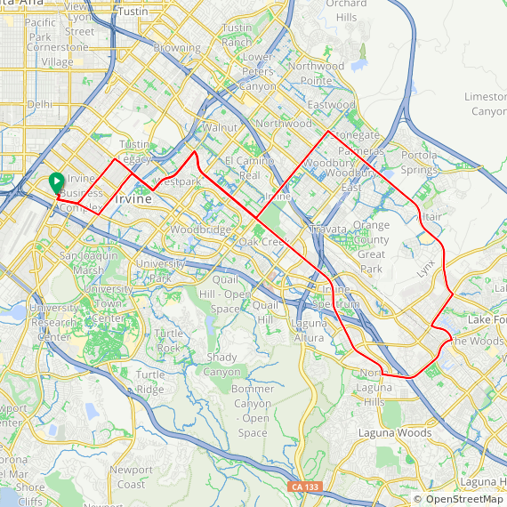
M28
38 Miles. Mostly rolling (with 1 hill) ride through Irvine, Laguna Beach, and Newport Beach, visiting 6 local bicycle shops.
M29

36 Miles. Flat to Rolling ride thru Irvine, Mission Viejo & Laguna Hills.
1300 Feet Elevation Gain.
M30

36 Miles. Rolling ride thru Irvine with a climb around Turtle Rock.
1000 Feet Elevation Gain.
M31

36 Miles. Flat to rolling ride thru Irvine, Lake Forest & Mission Viejo.
1700 Feet Elevation Gain.
M32

37 Miles. Rolling ride through Irvine, Lake Forest & Mission Viejo. About 1,100 ft gain
M33
35 Miles. Rolling ride thru Irvine, Lake Forest & Mission Viejo.
810 Feet Elevation Gain.
M34

37 Miles. Rolling to Hilly ride thru Irvine with all right turns.
1000 Feet Elevation Gain.

M36

37 Miles. Rolling to Hilly ride thru Irvine, Newport Beach continuing south to Laguna Beach returning up Laguna Canyon.
1450 Feet Elevation Gain.

M38

37 Miles. Rolling to Hilly ride thru Irvine, Laguna Beach & Newport Beach with a climb up Newport Coast.
1200 Feet Elevation Gain.
M39

37 miles. Flat to rolling ride through Irvine and Tustin. 850 feet elevation gain.
M40

37 Miles. Rolling to Hilly ride thru Irvine, Laguna Beach & Newport Beach.
1650 Feet Elevation Gain.
M41
37 Miles. Rolling to Hilly ride thru Irvine & Mission Viejo.
1150 Feet Elevation Gain.
M42

37 Miles. Rolling to Hilly ride thru Irvine, Lake Forest & Mission Viejo.
1000 Feet Elevation Gain.
M43

38 Miles. Rolling ride thru Irvine, Lake Forest & Mission Viejo.
1450 Feet Elevation Gain.
M44

38 Miles. Rolling to Hilly ride thru Irvine, Costa Mesa & Newport Beach.
1900 Feet Elevation Gain.
M45

38 Miles. Rolling to Hilly ride thru Irvine & Lake Forest.
1400 Feet Elevation Gain.
M46

38 Miles. Rolling to Hilly ride thru Irvine, Lake Forest & Mission Viejo.
1200 Feet Elevation Gain.
M47

38 Miles. Rolling to hilly ride thru Irvine & Mission Viejo.
1520 Feet Elevation Gain.
M48

39 Miles. Rolling to Hilly ride thru Irvine, Newport Beach, Laguna Beach & Lake Forest.
1500 Feet Elevation Gain
M49

39 Miles. Rolling ride thru Irvine, Newport Beach & Huntington Beach.
800 Feet Elevation Gain.
M50

39 Miles. Rolling ride through Irvine, Laguna Beach, and Costa Mesa, visiting 6 local bicycle shops.


M53

34 Miles. Mostly flat ride thru Irvine, Costa Mesa & Huntington Beach.
350 Feet Elevation Gain.
M55

42 Miles. Hilly ride thru Irvine, Tustin, Orange and Santiago Cyn.
2000 Feet Elevation Gain.
M56

33 Mile ride thru Costa Mesa, Huntington Beach, Newport Beach, Back Bay and Irvine Mountains to the Sea Trail.
L1
40 Miles. Hilly ride through Irvine, Mission Viejo and back
L3

41 Miles. Hilly ride thru Irvine, Lake Forest returning on Santiago Cyn and Tustin Ranch Rd.
2000 Feet Elevation Gain.
L3M
44 Miles. Hilly ride thru Irvine, Lake Forest, Mission Viejo returning on Santiago Cyn and Tustin Ranch Rd. 2500 feet of elevation gain.
L4

42 Miles. Rolling to Hilly ride thru Irvine & Mission Viejo.
1800 Feet Elevation Gain.
L5

43 Miles. Hilly ride thru Irvine, Mission Viejo, Laguna Beach & Newport Beach.
1900 Feet Elevation Gain.
L6

44 Miles. Rolling ride thru Irvine, Newport Beach & Tustin.
1700 Feet Elevation Gain.
L7

45 Miles. Rolling to Hilly ride north on SART with some climbing in Anaheim Hills area returning thru Orange, Tustin & Irvine.
3000 Feet Elevation Gain.
L8
46 Miles. Rolling to Hilly ride thru Irvine, Lake Forest returning on Santiago Canyon & Jamboree.
3000 Feet Elevation Gain.

L10

46 Miles. Hilly ride thru Irvine, Newport Beach Lake Forest with climbs up Spyglass, Newport Coast and Turtle Rock.
L12

46 Miles. Hilly ride thru Irvine, Lake Forest returning on Santiago Cyn & Jamboree Rd.
3500 Feet Elevation Gain.
L13

49 Miles. Hilly ride thru Irvine & Mission Viejo with a little climb up Vista Del Lago. Most of the original bike route for the 1984 Olympics.
2700 Feet Elevation Gain.
L14

50 Miles. Hilly ride thru Irvine, Lake Forest, Santiago Cyn & Orange.
3000 Feet Elevation Gain.
L15

50 Miles. Hilly ride thru Irvine, Lake Forest, Laguna Beach returning on PCH & Santa Ana River Trail.
1650 Feet Elevation Gain.
L16
45 Miles. Mostly flat Ride through Irvine, Costa Mesa, Tustin, Lake Forest, visiting 6 local bicycle shops.
L17

46 Miles. Hilly ride through Irvine, Laguna Canyon, Laguna Niguel, and Corona del Mar.
3000 Feet Elevation Gain.
L18

50 Miles. Rolling ride around Irvine, Newport Beach, Mission Viejo and up thru Santiago Canyon.
L19
53 Miles. Hilly ride through Irvine, Mission Viejo, Laguna Beach and Costa Mesa, visiting 8 local bicycle shops
L20

48 Miles. Mostly flat ride through Tustin, Orange, Anaheim Hills and Santa Ana River Trail. 900 Feet Elevation Gain.
L21
40 Miles - Ferry ride - bring $1.50 - rolling ride through Irvine, Newport Beach, Balboa Island and Balboa peninsula. 1200 Feet Elevation Gain.
L27
49 Mile ride thru Irvine, Irvine Spectrum, Baker Ranch, Lake Forest, Laguna Hills, Laguna Woods, Laguna Canyon, PCH, Corona Del Mar, Back Bay, Eastbluff, Bonita Canyon and University Town Center. 1700 feet of elevation gain.
L28

43 Miles. Flat ride thru Newport Beach, Huntington Beach, Seal Beach, Fountain Valley & Santa Ana.
400 Feet Elevation Gain.
L49

44 Miles. Hilly ride thru Irvine, Lake Forest, Santiago Cyn & Tustin.
2400 Feet Elevation Gain.
L50

47 Miles. Hilly ride climbing Turtle Rock, Summit Park, Newport Coast, Ridge Park, Pelican Hills with a cruise south on PCH for the final climb up Laguna Cyn.
3150 Feet Elevation Gain.
L51
50 Mile ride thru Irvine, Foothill Ranch, up Glenn Ranch, Mission Viejo, Lake Forest, Great Park, Portola Springs, Orchard Hills, Tustin Ranch and Tustin Legacy. 2400 feet of elevation gain.
L52

49 Mile ride thru Irvine, Lake Forest, Mission Viejo, Baker Ranch, Great Park, Portola Springs, Orchard Hills and Tustin Ranch. 2000 feet of elevation gain.
L53

43 Mile ride thru South Coast, Huntington Beach, Seal Beach with a return down PCH to Newport Beach, Costa Mesa and Santa Ana Heights. Coffee Stop at Creme Cafe in Seal Beach.
XL1

51 Miles. Flat to Hilly ride thru Santa Ana, Fountain Valley, Huntington Beach, Newport Beach & Irvine.
XL2

50 Miles. Hilly ride thru Irvine, Lake Forest, Laguna Hills, Mission Viejo, Rancho Santa Margarita.
3300 Feet Elevation Gain.
XL3

52 Miles. Hilly ride thru Irvine, Tustin, Orange, Villa Park, Anaheim Hills returning on the Santa Ana River Trail.
1750 Feet Elevation Gain.
XL4

52 Miles. Hilly ride thru Irvine, Newport Beach, Laguna Beach & Mission Viejo with climbs up Newport Coast, San Joaquin Hills & Laguna Canyon.
3000 Feet Elevation Gain.
XL5

55 Miles. Hilly ride thru Irvine, Orange, Anaheim Hills, Yorba Linda (12% grade up Hidden Hills), Villa Park & Tustin.
3500 Feet Elevation Gain.
XL6

54 Miles. Hilly ride thru Irvine, Lake Forest, Mission Viejo, San Juan Capistrano, Laguna Niguel & Laguna Hills.
3300 Feet Elevation Gain
XL7

55 Miles. Flat ride thru western Orange County to Long Beach and returning thru Seal Beach and PCH.
600 Feet Elevation Gain
XL8

54 Miles, Hilly ride through Mission Viejo, Rancho Santa Margarita, Laguna Niguel back to Irvine.
2100 Feet Elevation Gain
XL9

54 Miles. Hilly ride thru Mission Viejo, Santa Margarita, Laguna Hills returning thru the flatlands of Irvine.
2980 Feet Elevation Gain
XL10

54 Miles. Hilly ride thru Irvine, Tustin, Newport Beach and returning on the Santa Ana river trail thru Santa Ana.
XL11

55 Miles. Hilly ride thru Irvine, Lake Forest returning on Santiago Canyon.
3000 Feet Elevation Gain.
XL12

55 Miles. Hilly ride thru Santiago Cyn, Mission Viejo, Laguna Hills, Laguna Beach with a final climb up Newport Coast.
3500 Feet Elevation Gain.
XL13

55 Miles. Hilly ride thru Irvine, Lake Forest, Mission Viejo & San Juan Capistrano returning on Golden Lantern / Moulton Pkwy.
3700 Feet Elevation Gain.
XL14

55 MILES. Hilly ride through Tustin, Irvine, Santiago Canyon, Mission Viejo, Laguna Canyon, Laguna Beach, up Newport Coast, then through UCI.
XL15

56 Miles. Hilly ride thru Irvine, Trabuco Canyon, Rancho Santa Margarita, Mission Viejo & Lake Forest.
3700 Feet Elevation Gain.
XL16

58 Miles. Hilly ride thru Irvine, Mission Viejo, Dana Point with a little climb up Stone Hill returning on Crown Valley, Moulton / Irvine Center Dr.
2900 Feet Elevation Gain.
XL17

58.5 Miles. Hilly ride thru Newport, Laguna, Mission Viejo, Lake Forest 3560 Feet Elevation Gain.
XL18

58 Miles. Flat to rolling ride thru Irvine, Tustin, Orange returning on Santa Ana River Trail to PCH.
1200 Feet Elevation Gain.
XL19

58 Miles. Flat ride thru Western Orange County with a 10 mile stretch on the San Gabriel River Trail.
350 Feet Elevation Gain
XL20
59 Miles. Rolling to Hilly ride thru Irvine, Mission Viejo to Dana Point returning thru Laguna Hills
XL21
59 miles. Hilly ride through Irvine, Santiago Canyon, Mission Viejo, Aliso Viejo, Laguna Canyon, along PCH to Newport Beach. 3000 feet elevation gain.
XL22
60 Miles. Flat to rolling ride thru Irvine, Tustin, Orange Anaheim Hills returning on SART for 25 miles.
XL23

60 Miles. Hilly ride thru Irvine, Lake Forest, Mission Viejo, Rancho Santa Margarita with a fast 10 mile stretch on Antonio Pkwy.
2500 Feet Elevation Gain.
XL24

63 Miles. Rolling ride thru western Orange County, Los Alamitos, Long Beach, Seal Beach returning on PCH to Newport Beach & Irvine.
900 Feet Elevation Gain.
XL25
62 Miles. Hilly ride thru Irvine, Tustin, Orange, Yorba Linda up Carbon Canyon to Chino Hills and returning on the same route.
2750 Feet Elevation Gain.
XL26

63 Miles. Flat to rolling ride thru Santa Ana, Garden Grove, Seal Beach, Long Beach returning on PCH thru Huntington Beach & Newport Beach.
700 Feet Elevation Gain.
XL27
63 Miles Rolling ride thru Irvine, Tustin, Orange Santa Ana Cyn returning on the SART.
1100 Feet Elevation Gain.
XL28
64 Miles. Hilly ride thru Irvine, Mission Viejo, Rancho Santa Margarita, San Juan Capistrano, Dana Point & Laguna Niguel.
3500 Feet Elevation Gain.
XL28M

52 mile ride thru Turtle Rock, Shady Canyon, up the backside of Newport Coast, down San Joaquin to Marguerite and out Bayside to PCH, up PCH thru Newport Beach, Huntington Beach, Seal Beach to 2nd St and then back on Westminster, Springdale, Slater and Sunflower. This is the L28 long ride with some hills added at the beginning.
XL29

52 Miles. Hilly ride thru Irvine, Lake Forest, Mission Viejo, Santiago Canyon, Orange Park Acers, Villa Park, El Modena, North Tustin returning Tustin Ranch Rd. 2500 feet of elevation gain.
XL31
73 miles. Hilly ride to Mission Viejo, San Juan Capistrano, Dana Point. and back to Irvine.
XL32
75 Miles. Flat ride thru western O.C. and Long Beach riding on SART, San Gabriel River Trail, L.A. River Trail, Long Beach Bike Trail (along beach) and returning on PCH.
XL33
66 Miles. Hilly ride to 9 bike stores, through Newport Beach, Tustin, Irvine, Lake Forest Mission Viejo, Laguna Beach, and Costa Mesa
XL34
61 miles. Rolling to Hilly ride thru Irvine, Rancho Santa Margarita, Mission Viejo, Laguna Beach and Costa Mesa, visiting local bicycle shops.
XL36
65 Miles. Hilly ride through Tustin up Santa Ana Canyon to Weir Canyon and back through Orange, Tustin & Irvine. 4000 Feet Elevation Gain.
XL37

62 Miles. Hilly ride through Irvine, Dana Point, Ranch Santa Margarita and Foothill Ranch. About 4,300 ft gain
XL38
66 Miles. Hilly ride through Newport Beach, Irvine, Orange and Tustin.
XL39
73 miles. Hilly ride through Irvine, Mission Viejo, San Juan Capistrano, Dana Point, San Clemente, and Aliso Viejo.
About 3200 ft elevation gain.
XL40

54 Miles. Hilly ride thru Irvine, Lake Forest, Laguna Beach and Newport Beach with climbs on El Toro, PCH, Newport Coast, Pelican Hill & Ridge Park.
3200 Feet Elevation Gain.
XL41
68 Miles. Hilly ride through Irvine, Santiago Canyon, Rancho Santa Margarita, and San Juan Capistrano. About 3500 ft gain.
XL57

50 Miles. Hilly ride thru Irvine, Lake Forest, Laguna Hills, Laguna Niguel, Aliso Viejo with climbs up Pacific Island Dr, Pacific Park and Laguna Cyn.
4660 Feet Elevation Gain.
XL59
59 Miles. Very hilly ride thru south county with climbs up La Paz, Highland, Pacific Island Dr. returning thru the flat lands of Irvine.
3400 Feet Elevation Gain.
XL60
65 Miles. Hilly ride thru south county with climbs up Glenwood, Pacific Park, Oso and returning thru Santiago Cyn Rd.
XL61
56 Miles. Flat to Hilly ride thru Irvine, Newport Beach, Huntington Beach returning on PCH to Laguna Beach with a final climb up Laguna Cyn Rd. This is a TEMPO ride for intermediate riders capable of holding a uniform paceline at 18/22 MPH. Instruction will be provided throughout the ride.
1800 Feet Elevation Gain.
XL62

61 Mile flat ride thru Costa Mesa, Huntington Beach, Belmont Shores, out to the Light house in Long Beach and back thru Seal Beach, Huntington Beach, Newport Beach and the Back Bay.
XL83
83 Miles - Irvine to Mission Viejo, San Juan Capistrano, San Clemente, Dana Point, Laguna Beach, Newport Beach and Huntington Beach.
3500 feet elevation gain.
XL84

51 Mile ride thru UCI, Turtle Rock, Shady Canyon, Quail Hill, Irvine Spectrum, Laguna Woods, Aliso Viejo, Laguna Niguel, Laguna Hills, Lake Forest and Irvine. 2800 feet of elevation gain.
DIRECTIONS: THE SQUARE, IRVINE (1)
- Take the San Diego Fwy (405) to the MacArthur exit
- Go north 0.1 miles to Main Street.
- The Square is located at Main and MacArthur in Irvine near the John Wayne Airport.
- Park in the West Lot. (Where charging stations are located)